Barak UpdatesHappeningsBreaking News
Proposed map of Silchar Municipal Corporation released; last date for claims & objection 22 Oct
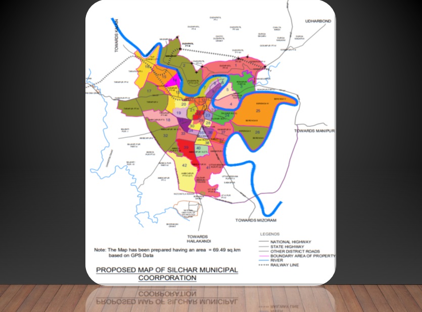
way2barak, Oct.10: The Cachar District Administration has released the proposed Map of Silchar Municipal Corporation (SMC). The Map has been prepared having an area 69.49 sq. km. based on GPS Data. Earlier, the area of Silchar Municipal Board comprised of 15.75 sq km. Along with the Map, the district administration has also come up with a data sheet wherein 42 Wards were proposed with a total population of 3,26,907. The population figure in each Wards were based on the Census Report of 2011. Inhabitants were asked to register their claims and objections, if any, in this regard by 5 PM on 22 October, 2022 through e-mail at : smb1882@gmail.com.
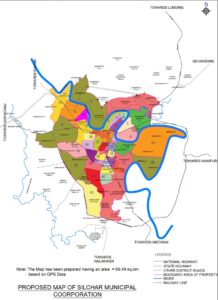 Proposed Wards of Silchar Municipal Corporation (SMC):
- Ward No.1: Population: 8,305; Proposed Household: 1,385
Boundary: North –Gossaipur IV, Part of Dudhpatil VII and Dudhpatil Grant
(F-24°51’29.17116″”E,92°49’21.09986″”N
G-24°51’33.1448″”E,92°49’42.90182″”N
H-24°51’9.08489″”E,92°50’26.66008″”N)
South – Barak River
East –Larsingkhal, Leburbond PWD Road
West –Village Rd & PMGSY Road. - Ward No.2: Population: 7,756; Proposed Household: 1,293
Boundary: North –Remaining part of Dudhpatil IV
(A-24°52’21.15188″”E,92°46’49.43273″”N
B-24°51’52.38032″”E,92°46’57.06502″”N
C-24°51’17.17628″”E,92°47’25.52125″”N
D-24°50’54.97472″”E,92°47’37.15522″”N
E-24°51’9.15448″”E,92°47’50.98754″”N)
South – Barak River
East – PMGSY Road Connecting to Rail Line via drain
West – Barak River and Natural Drain. - Ward No.3: Population: 8,360; Proposed Household: 1,394
Boundary: North – Mainarbond Road South – Barak River
East – Zero Point to Mainarband Road Point West – ADC Colony ( New Link Road) to Barak River via Bimal Dutta Lane. - Ward No.4: Population: 7,827; Proposed Household: 1,293
Boundary: North – NH37 South – Barak River
East – Barbhuiya Lane West – Barak River - Ward No.5: Population: 9,339; Proposed Household: 1,557
Boundary: North – Binoy Dutta Lane and Barak River South – NH37
East – ADC Colony ( New Link Road) to Bimal Dutta Lane
West – Barak River - Ward No.6: Population: 7,638; Proposed Household: 1,274
Boundary: North – Barak River
South – Adharnath Colony Main Rd (4th lane on the east from the intersection of Mela road and Steamerghat Rd and Debiprasad Road towards Malugram Jama Masjid) to Mela Road (Nabapally Lane Point – Lane next to Police Station) via Steamerghat Rd
West – Malugram Police Station Point to Shri Shri Gobindajeu Akhra Road via Nabapally Lane, Shibbari Road, Krishnanagar Lane (one lane after Samayik Prasanga), Malugram E & D Dyke
East – Barak River - Ward No.7: Population: 6,744; Proposed Household: 1,125
Boundary: North – Barak River (Annapurna Ghat) up to Chunabhatta Rd, Malugram
South – Trunk Road
West –Annapurna Ghat Road
East – Malugram E&D Dyke (Graveyard Point) to Drugs Corner Point via Swamiji Road, Malugram Road. - Ward No.8: Population: 9,539; Proposed Household: 1,591
Boundary: North – Road from Malugram PS to E&D Dyke. South – Swamiji Road
West – Malugram E & D Dyke (Swamiji Rd Point) to Chuna Bhatta Rd point
East – Malugram Road (BJP Office point) to Shri Shri Gobindajeu Akhra Road via to Malugram Police Station, Nabapally Lane, Shibbari Road, Krishnanagar Lane (one lane after Samayik Prasanga), Malugram E&D Dyke - Ward No.9: Population: 7,772; Proposed Household: 1,296
Boundary: North – Adharnath Colony Main Rd, to Mela Rd South – NH 37 (Sadarghat Road- Drugs Corner Point to Barak River)
West – Malugram Main Rd (Mela Rd to Drugs Corner Point)
East – Barak River (Adhar Nath Colony to Sadarghat) - Ward No.10: Population: 7,299; Proposed Household: 1,217
Boundary: North – Sadarghat bridge
South – Fatak Bazar Kalibari Road West – Janiganj Rd
East – Barak River - Ward No.11: Population: 7,007; Proposed Household: 1,169
Boundary: North – PWD Road (From Capital Point to Bar Library)
South – Gopalganj and UD Sarani
West –Park Road, Assam rifle internal Road, Jail Rd East – PWD Road (From Bar Library to Panpatty), via Janiganj, Dewanjee Bazar, Naazirpatty point, Gopalganj - Ward No.12: Population: 7,703; Proposed Household: 1,285
Boundary: North – Barak River and Trunk Road
South – DC Bungalow to Kalibari Road Tarapur (Via internal Assam Rifle Lane and Chandmari Road) West -Kalibari Road(Tarapur) to New Colony Shitala Mandir Road Via Station Road
East – Club Road and Park Road - Ward No.13: Population: 7,159; Proposed Household: 1,194
Boundary: North – Khudiram Sarani and Barak River South – Chirukandi Road (Up to 20 Feet Road)
West – Railway Line 2nd Gate and Chirukandi Rd (NH to deb para point)
East – New Colony Shitala Mandir Road and 20 ft Drain - Ward No.14: Population: 7,553; Proposed Household: 1,260
Boundary: North – Netaji Nagar lane South – Khudiram Sarani West – Railway Line
East – Barak River - Ward No.15: Population: 7,553; Proposed Household: 1,260
Boundary: North – Barak River
South – Development Complex Road Border West – Berakhal Rd to It Bhatta Road
East – Netaji Nagar Lane & Railway Line - Ward No.16: Population: 6,864; Proposed Household: 1,145
Boundary: North – Barak River. South – Berakhal Stream
West – Sheikh Para Road (ONGC store Road, Masimpur) and BSF Road
East – It Bhatta Lane (Near Tupkhana Madrasa, Near Jasir Mazumder House) - Ward No.17: Population: 6,964; Proposed Household: 1,161
Boundary: North – Development Complex road Border and Anua Lake border
South – Pechadhar Road
West –Tillagram Bagarkona Road East – Chirukandi Rd - Ward No.18: Population: 8,897; Proposed Household: 1,161
Boundary: North – Ashram Road Point to NH Bypass Via Deb Para (Das para) and Rangirkhal
South – Chencoorie Rd NH way Bybapass Via Nowaraj (Bhular Dukaan) and Rangirkhal
West – NH Bypass,
East – NH way ( Chencoorie Rd Crossing to Ashram Road Point) - Ward No.19: Population: 7,972; Proposed Household: 1,484
Boundary: North – TV Centre Road South – Satsang Ashram Road West – 20 Feet Drain
East – Vivekananda Road - Ward No.20: Population: 8,375; Proposed Household: 1,397
Boundary: North – Rail Line & NH37
South – Chandmari Rd to Industrial Area raod via lane next to TV Centre, Girish rd Tinali)
West – Railway Line (Industrial are to 2nd Gate)
East – Kalibari Road - Ward No.21: Population: 6,680; Proposed Household: 1,114
Boundary: North – TV Centre Road South – G C College Rd West – Vivekanada Rd
East – Police Family Lane, Adhar Chand School Boundary - Ward No.22: Population: 6,350; Proposed Household: 1,059
Boundary: North – Jail Road and U.D Sarani (Premtala Suruchi Point to Police Family Line, Jhalupara)
South – Ambicapatty G C College Rd (Chaitanya Press Point to G C College)
West – G C College Rd Point to Adharchand and Police Family Line
East – Hospital road (Suruchi Point to Chaitanya Press Point - Ward No.23: Population: 7,582; Proposed Household: 1,264
Boundary: North – Old Lakhipur Road(PNB Point) and Gopal Ganj South – Lochan Bairagi Road (Indraprastha Hotel to Durgabari, Bilpar)
West – NH 37 (Premtala Point to Suzuki Bike Showroom) East – Graveyard Road Bilpar - Ward No.24: Population: 9,816; Proposed Household: 1,637
Boundary: North – Barak River
South – Cheruyar Khal & Rangirkhal East – Kanakpur Road
West – Graveyard Road & GMC Road - Ward No.25: Population: 9,108; Proposed Household: 1,519
Boundary: North – Barak River South – PWD Road East – Barak River
West – Silchar Town - Ward No.26: Population: 6,998; Proposed Household: 1,167
Boundary: North –PWD Road South – Barak River East – Barak River
West – Kanakpur Pt I & II - Ward No.27: Population: 7,260; Proposed Household: 1,211
Boundary: North – Churyar Khal & Rangirkhal South – Swarupananda Lane
West – Shyamananda Lane East – E&D Dyke cum road - Ward No.28: Population: 7,073; Proposed Household: 1,180
Boundary: North – Lochan Bairagi Road South – Raangirkhal
West – NH 54 East – Singerkhal - Ward No.29: Population: 6,528; Proposed Household: 1,089
Boundary: North – Ambicapatty G C College Rd (Chaitanya Press Point to Subhash Nagar Point)
South – E&D Dyke Road (From point opposite Netaji School road to Subhash Nagar)
West – Subhash Nagar Road
East – Hospital Road (From Chaitanya Press point to Rangirkhal Small Bridge, Pointt opposite to Netaji School Road) - Ward No.30: Population: 6,318; Proposed Household: 1,054
Boundary: North – Subhash Nagar E&D Dyke (Rangirkhari Point) to GC College Rd (Panchayet Rd Intersection) via Subhash Nagar Ground
South – Das Colony West – Panchayet Road
East – Rangirkhari, Rangirkhal to Hailakandi Road (Das Colony Point) - Ward No.31: Population: 8,362; Proposed Household: 1,394
Boundary: North – Satsanga Ashram Road & G C Colleg Rd (National Highway Point to Gopal Dairy Point)
South – CR Avenue, National Highway (Udayan Coplex point to North Eastern Higher Secondary School)
West – National Highway, CR Avenue (North Easter Higher Secondary School Point to Satsanga Ashram Road Point). East – Panchayet Road and Udayan Complex (College Rd Gopal dairy Point to CR Avenue – National Highway – Udyan Complex Point) - Ward No.32: Population: 7,739; Proposed Household: 1,291
Boundary: North – Chencoorie Rd NH way Crossing to Bualjur Rangirkhal to Bypass via nowaraj
South – Jaroiltola to NH Bypass via Chandrapur Daspara West – Silchar Bypass
East – Hatirpath (NH Way to Kathal Rd) - Ward No.33: Population: 7,962; Proposed Household: 1,328
Boundary: North – National Highway
South – Kathal Road (hailakandi rd Point to Hatir path intersection
West – Hatir Path ( Kathal Rd point to National Highway Police station point)
East – Hailakandi Road ( National Highway Point) to Kathal Road point - Ward No.34: Population: 7,755; Proposed Household: 1,293
Boundary: North – Das Colony
South – National Highway (Medical Rd Point to Udayan Complex Point)
West – Udayan Complex (NH way point) to Das Colony
East – Hailakandi Road (Das Colony Point to National Highway Point) - Ward No.35: Population: 6,623; Proposed Household: 1,105
Boundary: North – Rangirkhari Point South – 1st Link Road West – Hailakandi
Road East – Sonai Rd - Ward No.36: Population: 6,372; Proposed Household: 1,063
Boundary: North – Rangirkhal to uttaranchal point South – Saratpally
West – Sonai Road
East – Uttaranchal Road - Ward No.37: Population: 7,282; Proposed Household: 1,214
Boundary: North – Kanakpur Road and Swarupananda Lane
South – Gouranga Paul Lane (Factory Lane) till E&D Dyke. West – Uttarancahal road to Sonai Road (Factory Road Point) via Sarat Pally
East – E&D Dyke - Ward No.38: Population: 6,255; Proposed Household: 1,043
Boundary: North – 1st Link Rd South – 2nd Link Rd. West – Hailakandi Road. East– Sonai Rd - Ward No.39: Population: 9,638; Proposed Household: 1,607
Boundary: North – Kathal Road (Hailakandi Road Point to Jaroiltola); South – Bualjur Khal Khal (ASEB Substaion to Pachgouri 2nd Bridge)
West – Jarailtola to NH Bypass via Chandrapur Daspara
East – Hailakandi Road (Kathal Road Point to ASEB Substation Bridge Ghungoor) - Ward No.40: Population: 7,317; Proposed Household: 1,220
Boundary: North – 2nd link Road (Hailakandi Road Point to Sonai Road Point)
South – Alitikar Road up to Basaikhal Drain
West – Hailakandi Road (2nd Link Road Point to Birbal Bazar Point)
East – Lane No 15 2nd Link Road - Ward No.41: Population: 11,625; Proposed Household: 1,938
Boundary: North – Border of Old Ward 14 (Factory Lane); South – NH Bypass
East – Barak River to NH Bypass Via Nagatilla and Shibalik Park Rd
West –Hailakandi Rd - Ward No.42: Population: 9,638; Proposed Household: 1,607
Boundary:North – Das para & Kathal Road; South – Silchar Bypass
East – Hailakandi Road West – Silchar Bypass.
Click Here for Detailed PROPOSED Plan for SILCHAR MUNICIPALITY COORPORATION