Barak UpdatesBreaking News
Fani likely to track northeastwards, heavy rainfall expected in next 24 hours

May 4: After devastating Odisha, Super Cyclone Fani entered Bangladesh through West Bengal. Since Fani has been moving inland in east-northeast direction, it has been constantly loosing strength. It is now seen as a deep depression over Bangladesh and adjoining Gangetic West Bengal. Fani is very likely to track northeastwards and move completely over Bangladesh but as weakened depression during next few hours.


The depression over Bangladesh moved east-northeastwards with a speed of about 29 kmph in last six hours and lay centred over Western Meghalaya and adjoining Bangladesh, about 110 km southeast of Dhubri in Assam and 130 km west-southwest of Guwahati. It is very likely to move northeastwards and weaken into a Well Marked Low-Pressure Area during next 12 hours.
 With this, rain intensity would now increase significantly over northeastern states today. In fact, Assam, Arunachal Pradesh and Meghalaya would come directly in the firing range of Fani, which would still have the power to give heavy to very heavy rains.
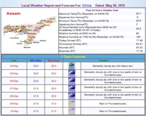
 As per India Meteorological Department, Barak Valley will also witness cloudy sky with one or two spells of rain or thundershowers. Possibilities of strong surface wind is also not ruled out by the weather department. As per skymetweather.com, by May 6, Fani would be seen as a feeble system only and would also move away by that time. As a result, weather would started clearing up but one or two spells cannot be ruled out.


